
The Shingle Desert: The History of Dungeness in the Twentieth Century
Abstract
Dungeness is a cuspate foreland on the south-east coast of Kent that is largely formed of shingle. In the twenty-first century Dungeness is a thriving tourist attraction, controlled by a number of organisations which utilise the land and co-existing amicably. This has not always been the case however, as in the past, military and nuclear installations have put considerable strain on the conservation efforts of the RSPB, who own and maintain much of the land, working hard to monitor and restrict activities that they consider too destructive to the area’s unspoilt natural beauty. At one time, tourists were deemed as much of a threat as shells from the military firing range established there, however, Dungeness has been able to survive the twentieth century as a landscape, almost as unique as it was a century ago, but due to a constant battle between conservation and other uses, it is no longer the untouched shingle desert it once was. Untouched implies unused, however, Dungeness in the twentieth century alone was used for military, nuclear, ecological and cultural purposes, existing as a home for man and nature alike, but also as an isolated base for defence and industrial development. Every use, including conservation, has physically changed the land, with only 28% of the shingle remaining intact by the 1990s. Had it not been for organisations such as the RSPB, the Central Electricity Generating Board and even the War Office, Dungeness may not have been as well preserved as it is today.
There is a considerable lack of writing on Dungeness by historians; what does exist is predominantly focused on specific events and is largely hidden among general information on nature reserves. This dissertation aims to compile one of the first comprehensive histories of Dungeness to bring to light the importance of this landscape.
Table of Contents
Abstract
List of Illustrations
Introduction
Chapter One: The Military and Nuclear History of Dungeness
Chapter Two: The Ecological History of Dungeness
Chapter Three: The Cultural History of Dungeness
Conclusion
Appendix I: Military Maps and Structures
Appendix II: Dungeness Nuclear Power Stations
Appendix III: Maps of the Nature Reserve
Appendix IV: RSPB Reserve Pits/Lakes
Appendix V: Denge Sound Mirrors
Appendix IV: Dungeness Bird Observatory
Appendix VII: Lighthouses
Appendix VIII: Fishing Debris
Appendix IX: Railway
Appendix X: Prospect Cottage
Bibliography
List of Illustrations
Image 1: Aerial View of Dungeness Today
Sourced from: https://theromneymarsh.net/dungenesshistory
Image 2: The Landscape of Dungeness Overshadowed by Powerlines
Sourced from: https://theromneymarsh.net/dungeness
Image 3: Lake at RSPB Nature Reserve
Sourced from: https://www.rspb.org.uk/reserves-and-events/reserves-a-z/dungeness/
Image 4: Elevated View of Dungeness from the Old Lighthouse
Sourced from: https://theromneymarsh.net/dungeness
Image 5: The East Side of Dungeness Today
Sourced from: https://theromneymarsh.net/dungeness
Introduction

Image 1: Aerial View of Dungeness Today
Dungeness headland is a National Nature Reserve, a militarised landscape, a home for nuclear power and a culturally important site all in one. Despite being relatively undeveloped, it is a landscape which, throughout the twentieth and this early part of the twenty-first century, has been important to many people. There are two local sayings, the first that Romney Marsh, which includes Dungeness, ‘is the fifth quarter of the globe,’ and the other ‘that Dungeness is the last place God made, and that he forgot to finish it.’[1] Both give some indication as to how unique Dungeness is, but without seeing it for one’s self it is hard to imagine quite how unlike anywhere else in Britain, and indeed much of the world, this shingle desert really is. Three aspects of Dungeness made it a particularly sought-after piece of land in the twentieth century; its existence as a habitat for a multitude of nature, most especially its attraction to birds, its isolation, and the fact that it is such a large undeveloped area. The people and organisations who purchased or tried to purchase the land however, had rather contradictory ideas as to what to do with it, which has only furthered its distinctive appearance.
Aside from any human interference, Dungeness is naturally a formidable landscape. It is uniquely vegetated with ‘600 species of plants,’ making it ‘the most diverse and extensive example of vegetated shingle in the country.’[2] Blackthorn is one of the most important plant species on the reserve, it is the only place in Europe where it grows out horizontally along the ground and not vertically as part of a Hedgerow.[3]The extreme flatness leaves Dungeness open to high winds off the sea which force vegetation to spread out at a low level, further adding to the distinctiveness of the landscape. ‘No other square mile of Britain has been created by nature so recently as the point of Dungeness… and research on its evolution may prove a key to [understanding] processes of coastal erosion and… rises and falls in sea level.’[4] The shingle is ‘dominated by flint which provides a unique environment for a number of rare species of plants,’ birds and animals, such as the Great Crested Newt, one of the most highly protected species in Europe, and the Sussex Emerald Moth. It also provides ‘critical evidence for coastal erosion’ and a record of climate change, however, without human intervention, this incredible natural landscape would have been destroyed throughout the last century. [5]
The protection of Dungeness and its shingle ridges by a number of organisations is critical to preserving this valuable source of environmental data and the important habitats that it provides. Since the early 1900s, The Royal Society for the Protection of Birds, (RSPB), has, to the best of their ability, played a critical role in preserving this haven for nature. Dungeness was their first nature reserve and its protection has been critically important for many people both inside and outside of the Society, nevertheless, as a relatively uninhabited coastal area, the isolation Dungeness offered also brought it to both military and nuclear attention. Its military history stretches as far back as the Napoleonic Wars, when it was used for defensive schemes, but the landscape was most affected by military use in the 1940s. Requisitioned by the War Office during the Second World War for use as a military training ground and firing range, the untouched shingle became pockmarked by craters left by exploded shells. Additionally, in the 1960s, the Central Electricity Generating Board (CEGB) built the Dungeness nuclear power stations, which now loom over the landscape, on top of the shingle ridges that many wished to protect. This was a controversial and heavily protested move which forced a decision to be made between the importance of human progress and that of nature conservation. Nevertheless, despite the pressure both the War Office and the CEGB put on preservation efforts, without their presence at Dungeness the land would have faced considerably worse threats.
Today, the heritage of Dungeness sprawls out over the expanse of shingle surrounding the nature reserve and power stations, with remnants of its railway and fishing pasts, alongside the lighthouses and the cultural legacy of English film director Derek Jarman still remaining. Although Dungeness has a reputation as an isolated and untouched terrain, today the landscape is considerably less untouched than it was a century ago, as the twentieth century was a constant battle between conservation and all other uses.
This dissertation shall therefore explore the history of Dungeness in the twentieth century through its military, nuclear, ecological and cultural uses and will examine how those uses coordinated with or opposed each other, how they have physically shaped the Dungeness that residents and visitors see today, and why such human intervention has been necessary in its preservation. I chose this topic as, being from Kent myself, I was keenly interested in this unique cuspate foreland that is part of my home county and yet so unlike anywhere else within it. I used to go for daytrips there with my grandparents as a child, however without this dissertation it would have always remained simply a tourist attraction to me and I felt that there was a deeper history behind the large expanse of debris and shingle than visible on the surface. This dissertation is primary source led, as little has been written about Dungeness, and what has been written is quite disparate. My difficulty in finding the exact year, let alone decade, that Dungeness finally became a National Nature Reserve can attest to how inadequately documented its history is. It is due to the considerable amount of historical correspondence that I read in my research however, that I feel that I can adequately attest for the competing views, different perceptions, and changing values of the people and organisations involved in shaping Dungeness.
Due to the Covid-19 global pandemic, I was unable to return to the archives for a third time, so there are some gaps in the research, most especially in the ecological chapter. Although my research is more limited after the 1960s, it provides clear comparison between approaches to the landscape then, and the tourist-based Dungeness that exists now in the twenty-first century. The jump highlights how visitors to the area have turned from being thought of as a potential threat to what is now a target audience; the extent that these organisations have physically shaped the land; and how threats to conservation efforts in the long run have perhaps not been as aggressively negative as originally thought.
Chapter 1: Military and Nuclear History

Image 2: The Landscape of Dungeness Overshadowed by Powerlines
The isolation of Dungeness is what attracted both military and nuclear attentions in the twentieth century. The War Office utilised the open space during the Second World War for military training purposes, whilst the relatively small number of human inhabitants also attracted the CEGB in the latter half of the century for nuclear energy. Both organisations, with their presence seen as hostile, inflicted a relatively negative impact on the landscape; with shingle destruction and inconvenience to the RSPB’s preservation efforts it cannot be said that the landscape went unscathed. Without pressure from the RSPB, especially with regards to the War Office, there would have been no consideration for the damage being inflicted, and today Dungeness may have simply existed only as just another generic seaside town, or nothing more than an empty, pock-marked beach, abandoned for all uses except for that of nuclear power. However, despite their perceived negative impacts, with the RSPB restricting the amount of damage they could impose, the presence of both the military and the CEGB has also resulted in some unexpectedly positive outcomes.
The Military Impact
Dungeness’ military history stems back considerably further than the World Wars, as, ‘given its closeness to the continent, the easily accessible beaches of the Romney Marsh had always been vulnerable to a foreign attack.’[6] Dungeness’ military importance in the early nineteenth century is clearly demonstrated by the fact that the very first Ordnance Survey Map, The William Mudge Map of 1801 [See Appendix I], covered the area of Kent and Dungeness. The map’s production ‘was dictated by military need’ ‘due to the threat posed by the French during the French Revolution.’[7] Dungeness became ‘home to a number of defensive structures in response to the… threat during the Napoleonic Wars’, for example a number of gun batteries, some of which were used again during the First and Second World Wars. Battery 2 was ‘reused during both World Wars as a site for anti-aircraft guns,’ and this site has now been converted into a block of coastguard houses [See Appendix I]. [8]
‘The First World War shifted attention away from any embryonic’ interests in conservation which created difficulty for the RSPB’s conservation efforts at Dungeness.[9] While the military were considered a threat to these efforts, relationships between the military and the RSPB were amicable enough to ensure that any serious damage was able to be avoided. Aeroplanes were constantly flying at low level over the birds’ breeding ground, ‘but the birds were apparently undisturbed by them’ and, ‘though there were large numbers of troops near the birds, the soldiers, after being spoken to, were “very good in not disturbing the birds or taking the eggs”.’[10] Whilst the military presence was an obvious inconvenience, they made considerably little impact to the area during the First World War and, aside from annual training of the Tank Corps, Dungeness was then untouched by military necessity for the next 20 years.
Dungeness played its main military role of the twentieth century during the Second World War. ‘The whole reserve was occupied by the military and suffered so heavily that serious doubts were felt regarding the possibility of its recovery.’[11] As soon as the War Office arrived, their presence was felt, with a letter from the RSPB warden stating that ‘The army are certainly taking a whacking great slice of this part of the Dengemarsh Beach sector of the Reserve. Their acquisition includes part of the ancient ternery area and the best sites for the Stone Curlews and Common Gulls.’[12] Yet, whilst from a conservation perspective their presence was a disturbance, from a military perspective Dungeness was a very successful location. By 1939 ‘negotiations were preceding between the RSPB and the War Office with regards to leasing a very small portion of the Society’s property’ but by 1940 a significant amount of the land had been requisitioned by the War Office.[13] Certainly, Dungeness played an important role during operation PLUTO in 1944, which was ‘an operation by British Engineers and Oil Companies… to transport fuel under the English Channel into France in support of Operation Overlord, the allied invasion of Normandy.’ As Dungeness was ‘in range of the German guns’ the operation was particularly dangerous here, and terminals and pumping stations had to be ‘disguised as bungalows, gravel pits and garages’, today known as “PLUTO bungalows”, many of which have become private residences. The operation’s ultimate success meant that ‘by the end of the war an estimated 172 million gallons of fuel had been supplied to the Allied forces in France’, but, even on a day-to-day basis, the isolation of Dungeness enabled it perform perfectly as a site for military training and an artillery firing range. [14]
After the Second World War, the War Office had a continued presence at Dungeness, keeping the land requisitioned until the late 1950s. Unlike after the First World War, their wartime efforts had left physical evidence, as the shingle was ‘battered’ and ‘pock-marked’ and the number of birds significantly diminished.[15] For military purposes the land continued to be a perfect location, however, it brought with it decades of considerable rehabilitation work for conservation organisations and even by 1956, over a decade after the end of the war, the bird population had still ‘not recovered from the affects.’[16] In peacetime, the RPSB and the military had rather contrasting views on what should be the main focus for using the land. Accounts of the military after the war describe them as a ‘curse’, with ‘wild’ mortar-firing leading to bombs landing ‘well outside’ of the enclosed area and the mortar range fence enclosing ‘almost all of the gullery.’ Furthermore, their construction of a concrete tower on requisitioned land in 1955 indicated that they were planning to be ‘in possession of the best part of the reserve’ for quite a considerable time.[17] The land cordoned off as a ‘Target Area’ came under scrutiny by the RSPB when the War Office began investigating the purchase of some of the already requisitioned land. The RSPB claimed it to be the ‘most important part of Dungeness from a nature conservation point of view’ as it was ‘the last bit of coastal land still in its pristine state, untouched except by shell craters in places, and therefore of national importance.’ They argued that they would object to anything other than its retention solely ‘as a wartime emergency area’, stressing the importance of it not being ‘disturbed or disfigured as so much of Dungeness [had] already been by the [War Office], who [held] most of the promontory.’[18] The fact that the War Office appeared to be encroaching more permanently on the reserve and the surrounding land created uncertainty and anxiety, as their presence had the potential to destroy all of the preservation efforts from previous decades.
With the threat of war gone, however, a level of care was given by the War Office with regards to the local area, and communication between the RSPB and the War Office enabled some guidelines to be put in place to avoid destruction where possible. Naturally the occupation of the Armed Forces ‘prevented normal work in most of the Society’s lands’ however, ‘helpful cooperation’ left the birds more or less undisturbed in some places.[19] Moreover, during the period when the War Office were looking to purchase some of the requisitioned land, correspondence shows that amicable negotiations occurred between the parties, in order to achieve a situation that was best for both conservation and military purposes. The RSPB were ‘strongly in favour of the [War Office] keeping a hold on’ the land, ‘thus preventing any developments’, but they wishedto ‘keep the front shingle land clear for their own interests.’ They proposed the War Office should retain hold of the land by agreement as opposed to an outright purchase, this would both save the War Office money and would enable the RSPB to maintain their conservation work on this area. Ultimately, amicable relations meant that caution was taken to prevent any unnecessary damage and ‘it is probably due to the continued presence of the military… that we owe the preservation of what is left of the Dungeness shingle beach.’ [20]Dungeness’ military history caused severe damage and disruption over the years, but it also kept developers off the land who arguably would have caused far more long term damage, as significant increases in new residents to the area would have posed an almost uncontrollable threat to the conservation efforts of the neighbouring nature reserve.
The Nuclear Impact
The disruption by the military in the 1940s and 1950s however, was not the end of Dungeness’ history with regard to industrial uses of the land, as the 1960s saw the start of construction of two nuclear power stations: Dungeness A and Dungeness B. The isolated area made it a prime site, at a time when ‘the public, scared by the very word nuclear, sought to relegate the new power stations to coastal sites away from settlements’, and the enthusiasm towards conservation, ‘so evident immediately after the war, [also] was beginning to fade.’[21] Despite this however, contestation was made that this was an ecologically important landscape and it would affect the efforts of the RSPB’s nature reserve. When the Government were considering the construction of the first nuclear power station at Dungeness, ‘the Nature Conservancy (NC) [took] the unprecedented step of opposing the application at a public enquiry.’ ‘Formal application was made to the Ministry of Power, in June 1958, for consent to build a 500/550 MW nuclear power station’ and immediate notice was given of the NC’s opposition. The Conservancy ‘had accommodated all previous proposals for nuclear power stations’ however in their opinion ‘the scientific interests at Dungeness were simply too high for concession and compromise to be possible,’ and furthermore ‘the site chosen for the power station was the least-damaged part of the shingle promontory.’ They took the position that ‘no matter how magnificent a power station might be in itself, nothing could compensate for its intrusion’, however, ‘after a pitched battle’ the NC lost.[22] ‘The preservation of wildlife…was only one of the factors’ that the minister had to consider but he deemed the need for power was more important. ‘The Inspector’s report reasoned that the station would occupy only 10 per cent of the proposed National Nature Reserve at Dungeness… [but] the key area for research on the shingle ridges would…be permanently destroyed.’ However, in the end, ‘as Dungeness was claimed to be the only suitable location’, the minister announced his consent in 1959.[23]
Dungeness A, a legacy Magnox power station, was connected to the National Grid in 1965. Dungeness A was ‘one of the world’s first commercial nuclear power stations’ making Dungeness ‘justly famous’ for being ‘in the vanguard of technological innovation.’[24] Nevertheless, in January 1980 the plant shut down for a two year period, as it was said to be in an unsafe condition for operation as there were defects in the welds of the cooling circuit. By the end of 1981 the press had launched an attack on the decision to bring back Dungeness A without doing what they considered to be ‘full tests or repairs.’[25]Whilst the CEGB deemed all allegations to be ‘completely untrue,’ the press argued that there were ‘serious doubts surrounding its safety given the known facts,’ and furthermore argued their doubts could not be ‘dispelled by CEGB’s reiteration of its own confidence in its safety, as [in their view] the CEGB’s track record [was] nowhere near as good as it likes to pretend.’[26] Whether the allegations were true or not, it caused serious concern among the local people and was not helped by the CEGB’s secretive nature towards information on nuclear energy. Furthermore, Hastings Constituency Liberal Party ‘called for an end to secrecy over faults’, expressing their concern over ‘environmental issues.’ They claimed, ‘when both reactors are operational, two tonnes of irradiated carbon dioxide coolant escapes daily’ and called for ‘a truly independent examination [to be] funded by the Department of the Environment.’[27] Nonetheless, despite the opposition, the power station was restarted and continued to operate until late 2006. The impact on the land by Dungeness A however has still not finished. ‘Defueling was completed in 2012 and the demolition of the turbine hall later in 2015. It is now expected to enter the “care and maintenance” stage of decommissioning’, but this will not be until 2027.[28]
As Dungeness A started operation in 1965, construction of Dungeness B began, becoming ‘the first Advanced Gas cooled Reactor (AGR) in the United Kingdom.’[29] Whether, due to a lack of public information, or a general uncertainty among both engineers and locals alike, no one seemed able to ascertain how long after it was due to open that it would be until it became operational. In 1981, newspapers claimed it could be anything from 6 to 11 years. One thing that they all agreed on is that it took significantly more time and money than originally intended. It was said that the years of delay were caused by ‘design trouble, technical and labour problems’ and other industrial issues.[30] Dungeness B had been a ‘very early design’ and so there had been issues from the start, largely due to it being one of the first power stations of its kind, however, other errors were made which also slowed down construction.[31] There was concern over ‘unsafe practices including the way sensitive stainless steel [was] handled and the use of potentially damaging marker pens.’ Furthermore, it was also claimed that seawater had caused severe corrosion of the cooling system and Councillor John Brooke declared that it showed a ‘lack of standards.’[32] Nevertheless, Dungeness B finally started operation in 1983 and is still operational today. ‘In 2005 the stations [proposed] closure date was set for 2018 but in 2015 the plant was given an extension of ten years, taking the closure date to 2028.’[33]
Dungeness’ existence as a nuclear site was almost renewed once more with proposals for the construction of Dungeness C. In 1981 it was considered to be highly controversial due to the likelihood of it being an American designed pressure water reactor, the like of which had already seen ‘a major accident 2 years prior at Three Mile Island, Harrisburg, in the United States.’[34] In 2009 the issue came up again when Dungeness was included on a list of 11 potential sites for a nuclear power station, this time however, due to environmental reasons, ‘Dungeness C was not included in the Government’s draft National Policy Statement, and was later ruled out in 2010 by the Secretary of State for Energy and Climate Change.’[35]
Whilst it is hard to know the extent of the damage the introduction of the power stations has had physically on Dungeness, until they are finally removed, it can be assumed due to their size [See Appendix II] that it will be significant. Considering the shingle area that they occupy was the least damaged before their construction, the concrete foundations alone will have destroyed any hope of returning the land to its pre-nuclear condition. Furthermore, the impact that the radiation has had on the land cannot even start to be measured. In 1981 there was a report of several kilograms of plutonium, with one millionth of a gram being enough to be fatal, going missing, with one theory being that it may have escaped through cracks in the structure.[36] Whilst not proven, if this was true, then the long-term effect on the flora and fauna could be beyond rehabilitation efforts. Slightly mutated flora has already been found, which only indicates that even if the radiation levels are perfectly safe, it is still strong enough to mark the landscape. However, while the nuclear power stations would not appear to have had any benefit to a landscape of such ecological importance, where conservation work is ongoing, they have not been the disaster that was predicted by the NC in 1957. When asked about any negative effects from the proximity to the power stations, the RSPB surprisingly now consider them to be a welcome neighbour, as the warming effect on the water attracts fish for the birds who seek sanctuary there.[37] Socially, Dungeness B was employing ‘550 operating and technical staff’ in 1981 before it even started operating, and 50 further jobs were created when it joined the grid.[38] Today, it is ‘the largest employer in Romney Marsh’ and also brings money to the local economy as a tourist attraction, which offers ‘a visitor centre and guided tours of the station.’ It is now considered an iconic landmark which ‘makes significant contribution to the local character’, considering its vertical presence on an otherwise flat landscape.[39]
Of all the ways in which the land has been used, the historical use by the military and nuclear industries are by far the most damaging physically. The concrete foundations used for both the power stations and all of the buildings and roads made by the military, the extreme destruction caused by shells and tanks, and the perhaps unseen effects of the radiation on the wildlife, cannot be considered as anything but negative and the presence of both organisations will undoubtedly leave huge scars. They have however, been kept in check by the RSPB, the NC and the press, and, the military presence at least, saved Dungeness from a potentially worse fate. Dungeness’ military and nuclear histories are controversial, as from a standpoint of national pride and progress Dungeness is a site worthy of praise. It managed to support the military in their training and defensive schemes, survive the pressure the land was placed under, and become a site of innovation by leading the way forward in nuclear power with both Dungeness A and Dungeness B. However, the area is too ecologically important to simply be considered as any ordinary landscape, and for many, the damage cannot be written off in the name of progress.
Chapter 2: Ecological History

Image 3: Lake at RPSB Nature Reserve
Dungeness is a prime location for ornithological, botanical and entomological interests with a spectacular array of flora and fauna. During the twentieth century, conservation was arguably the most important and influential use of the land, as the RSPB, and later the Bird Observatory and the NC, asserted their presence. The RPSB purchased the majority of the land and had significant correspondence with every other organisation who considered it a useful site. Despite the significance of the shingle and plants in their own right however, for most of the twentieth century the primary focus of the RSPB was based entirely on the birds. It is a natural habitat for migratory birds and, ‘among a number of uncommon breeding species it has the only nesting colony of Common Gulls in England and Wales, and the only considerable colony of Herring Gulls established on shingle.’[40] Due to its importance to a number of bird species, the RSPB felt its protection and preservation was essential, and so in 1896 ‘the Kent County Council obtained an order to designate the area as a sanctuary and the RSPB appointed a Watcher.’[41] However, the sanctuary was significantly smaller than the land held by the Society today due to additional land being purchased after the 1920s.
Conservation was not as popular at the beginning of the twentieth century as it was by the end, yet in 1919, Country Life wrote that Dungeness was a ‘place worth protecting properly’, and through the 1920s local feeling grew strongly in favour of the preservation of the wild birds.[42] The workload of the part-time Watcher became much heavier as Dungeness saw a considerable increase in visitors, eager to see the sanctuary that had become famous for its large sea-bird population, but the Society’s preservation of the area was not totally safe from threat. With supplies scarce around the end of the First World War, Government Authority sanctioned the collection of “Gulls’ eggs” as a source of food. Dungeness was already a ‘notorious haunt of [egg] collectors; but for the RPSB, some of the rarer species would have followed their less fortunate associates of former years into oblivion’, but this sanction only made the problem worse.[43]
Furthermore, the increase in visitors brought with it fresh roads, more foot traffic and worst of all new houses. ‘During the 1920s, there was an increasing danger of the more accessible parts being developed for housing. Matters came to a head in 1925 when 1,100 acres of the eastern side of promontory were offered for sale.’ The RSPB planned to gather all interested parties to raise sufficient funds, with a plan to buy it and hand it over to the National Trust, however, they could not find the wherewithal to buy the place outright, nor did they ‘have faith in a fundraising campaign.’[44] They believed that ‘a public appeal for the purchase of Dungeness as a bird sanctuary would be a complete waste of ‘money, time and energy’ noting that its ‘birds and desolation would not appeal to the British public in the least, but only to a limited number of people who [cared] about fauna and wild places.’ [45] Ultimately the shingle was withdrawn from sale, however this incident made the RSPB begin to consider the necessity for further land purchases.
1927 brought great anxiety over the safety of the birds in the area. The Hythe and Dymchurch Light Railway was extended to Dungeness, [See Appendix IX] but an amicable conference with the owners ‘resulted in the line being so laid as to avoid any interference with the Plover’s nesting ground’ and the gangers were encouraged to act ‘in conjunction with the Society’s Watchers.’[46] However, with travel to and from Dungeness now more convenient, ‘the light railway to Dungeness was followed by extensive bungalow development… along four miles of sea frontage’ and, alongside the extra visitors that the railway transported, this demonstrated that despite the RSPB’s influence, the nesting grounds of the birds were not necessarily safe from the use of the land by others.[47] Furthermore, while ‘numbers of oiled birds [had] been washing up on Dungeness beach’ throughout the 1920s, in 1927 oil issues were particularly prevalent and ‘countless birds perished miserably.’[48] These were two of a number of factors which inspired the purchase of the ‘nucleus of a Bird Sanctuary’ in 1928, and the addition of a ‘further 120 acres’ by 1930.[49]The creation of a sanctuary meant that the RSPB had a place to effectively care for the oil covered birds, but it also provided them with a legal right to prevent trespassing on the land if visitors became too great a threat.
An important player in the development of the Nature Reserve was a Mr. R.B. Burrowes who purchased significant areas of land for the purpose of preservation, almost bankrupting himself in the process. ‘Mr. Burrowes’ personal monetary sacrifices culminated in the formation at Dungeness of a Bird Sanctuary of approximately 1,000 acres in extent.’[50] He was an independent buyer and not initially affiliated with the RSPB, but he gave them shared ownership of much of his land for exceptionally minimal compensation. In 1929 he cheaply purchased a small farm with a long frontage and in 1931 ‘he, with the help of two generous ladies, purchased a further 253 acres,’ called Walkers Outland, and donated this to the RSPB [See Appendix III]. Without these two purchases, the middle of the promontory would have been at risk of ‘spoliation.’ [51]
After ‘speculators bought most of the east side’ in 1925, Mr Burrowes purchased a further 271 acres of mostly shingle at Greatstone [See Appendix III] for £8850 in 1932 to ‘stop bungalow spreading.’[52] This land was bought on the condition that the vendor agreed ‘to leave a right of way… along the shore and through the new reserve as a rough track,’ however, the vendor soon bought land to the south of the reserve and ‘straightaway broke the covenant and converted the track into a road.’ This ‘completely ruined the purpose of the reserve’ and so in 1935, after a ‘protracted legal dispute, the vendor was forced to repurchase the moribund reserve… for the original sale price.’[53] Fortuitously, the War Office later commandeered control of this land, meaning that no housing developers could use it, which would have been arguably more damaging to the shingle than shells and tanks. Furthermore, £2100 of the money returned from this sale was spent on securing a separate 280 acres of shingle in the middle of the promontory, which contained two small lakes, saving this land from ‘the threat of bungalow building’ that had begun to encroach.[54] At this point ‘only one more purchase of 730 acres with 1 ½ miles of sea front [was] required to make the whole place safe,’ as the War Office owned 6 miles on the weir which was ‘practically untouched’, making it unusable to others.[55]
Due to the unenclosed nature of the land, it required several part-time Watchers to tackle the everyday threats that their preservation efforts faced, but the Watchers assigned by the RSPB worked gallantly and took pride in their jobs. Egg-collecting, trespassing by curiosity seekers and the potential for spring and summer visitors to wander too closely to nests were three concerns that required constant attention. One particular benefit of Dungeness is its ‘extreme flatness’ which ‘[facilitated] the protection work’ as an account by a visitor, Mr Landsborough Thomson explains, it meant that visitors could be ‘easily seen and challenged.’[56] Management work was intended to both ‘preserve and enhance wildlife’, however Watchers could only achieve this on land that was owned and under the protection of the RSPB, which is why the acquisition of the final 730 acres was of such importance to guaranteeing the preservation of the whole area.[57] Enquiries into the possibility of this began in 1936 and in 1937, with the help of Mr. Burrowes, the purchase of the 730 acres of land on the west side of Dungeness was completed. Thus, by the end of the 1930s, ‘1233 acres of shingle and sparse shrub’ existed as a nature reserve under the RSPB and they were in a position to look ahead to their future.[58]
In 1940 the War Office requisitioned the RSPB’s land and continued to hold sections of it until the late 1950s. Their use of the land during wartime as a range ‘had so severe an effect on the colonially breeding birds’ that by 1951 ‘colonies were found to have been very nearly depleted and no young were being reared.’[59] The birds were in such a precarious position after the war that no visitors were allowed to Dungeness in order to reduce the risks to the birds, their nests and their eggs. Considering the multitude of visitors that flock to the reserve annually in the twenty-first century, it is difficult to imagine a time when visitors were not welcome, but this excellently demonstrates that the RSPB’s presence has always been first and foremost about conservation. However sometimes conservation efforts have meant protecting wildlife in non-ideal circumstances as a compromise against a situation that would be considerably more harmful and difficult to monitor. Therefore, despite the devastating effect on breeding, the presence of the War Office was not considered to be entirely negative after the war. In 1949 Mr Burrowes wrote that ‘the interests of nature conservation and the [War Office] are not conflicting in some respects as they have a strong common interest in keeping building and other developments off the area.’[60] Thus the shells cratering the land and disturbing the breeding birds was considered less of a threat to conservation efforts than the development of the surrounding area, which would have brought with it significantly greater human presence and a loss of undamaged shingle.
The War Office was not the only Government department that the RSPB were in regular contact with. The Nature Conservancy was set up by Royal Charter in 1949 in order to investigate places that could have been potential National Nature Reserves and areas of high scientific importance. Dungeness fell into both of these categories, and theoretically, to declare it as a National Nature Reserve would give it the Crown’s protection, thereby safeguarding ‘the scientific interest’ and affording protection ‘against possible future harmful development or encroachment.’[61] As the NC was a Government organisation, they were kept ‘in close touch with proposals made by other departments’ and with their support, the RSPB would be in a significantly stronger legal position to defend the land.[62] Relations between the NC and the RSPB were built during the 1950s, during negotiations about how Dungeness, as a National Nature Reserve, would be managed legally and financially. The aim of both organisations was to restore Dungeness to the thriving ornithologically important landscape that it had been before the War Office’s requisition of the land.
The involvement of the NC at Dungeness in the 1950s helped the Watchers and the RSPB make significant progress in their post-war rehabilitation process. In 1952 ‘the [NC] made a grant to the [RSPB] to employ a full-time Watcher, Mr H.E Axell, in order to experiment with various methods of management which might restore the [reserve] to its former importance.’ Within the first year, due to the presence of this full-time Watcher, the policy of limiting human access to the area was successfully accomplished ‘through the cooperation of local persons, the spreading of propaganda, the erection of notice boards and persistent interception of trespassers. It was thus possible, in 1953, for the Watcher to undertake further research into the effect on the birds of natural predators’ which had become the latest threat. [63]
The 1950s saw significant change to the landscape as the RSPB moved away from simply preserving what already existed and moved towards designing a better site for the birds. After the war, the new threat to the birds were natural predators, mainly foxes, hedgehogs and crows, which had increased in the area ‘to achieve a balance of power which they did not enjoy before the war.’[64] They were thwarting rehabilitation methods imposed by the Watchers and, with usual coping methods showing no success, in 1956 the RSPB considered the possibility of excavating a lake. They intended the lake to be ‘approximately ten acres’ and feature ‘three fairly large islands’ in the middle for the birds to nest and breed on, free from the threat of predators [See Appendix IV].[65] However, this was a significantly more complicated process than first considered, owing to complications over the lake’s placement, the continued presence of the War Office and the importance of the birds being undisturbed during the breeding season.
The Kent River Board and the Folkestone and District Water Company had contrasting views on where the lake would be best placed. ‘The Folkestone Water Board [seemed] anxious that this lake should be on the west side’ and suggested the possibility of enlarging the already existing pits, as moving any closer to the Denge Marsh sewer or the east side ‘would almost certainly cause the water to escape from the shingle into the sea more rapidly than it’ did already.[66] On the other hand, ‘the Kent River Board [preferred] to see it dug [on] the east side of the Denge Marsh sewer’ as they were concerned with the lake being ‘far enough from the sea-wall to avoid weakening it.’[67] The main concern for the RSPB was that it should be as close as possible to the breeding ground of the Terns.[68] However, even once the location for the lake had been agreed, the War Office needed to retrieve all unexploded shells before excavation could start and ‘furnish a certificate of clearance.’ Moreover, they needed to decide how much of the area would be derequisitioned, and the concrete road that they had built during wartime, which lay ‘ca. 300 yards eastward from Dengemarsh road’, was a parameter that the lake could not disturb.[69] Excavation companies were keen to extract the shingle, for which the RSPB were prepared to take fairly low offers due to the abnormal working conditions as ‘they would be prevented from working for a good bit of the spring and summer while mortar-firing [was] taking place, and they would have to stop in the breeding season’ once they got near to the ternery site.[70]
Eventually the project was completed, and it was the first of a number of lakes that still provide safety from predators and visitors alike. The building of these pits is considered to be controversial today, as its costs, arguably to some, outweigh its benefits. The excavation of the shingle ‘paid off financially as well as ornithologically’ as it ‘created jobs for the locals, revenue for the Society… and an enhanced habitat for the birds.’[71] However, the shingle itself is ecologically very important as it is ‘the home to a number of extremely rare species’ of plant, ‘including one probably extinct everywhere else in Britain’, and ‘it is also very favourable for insects.’ ‘Few of Britain’s Nature Reserves can look more bleak and unprepossessing, but few contain a wider variety of scientific interest’ and all of the scientific and ecological interest is contained within the shingle.[72] The excavation of the pits demonstrated the RSPB’s lack of concern towards non-avian wildlife, while ‘other conservation bodies… let it happen’ and, as a consequence of this, only ‘twenty-eight percent’ of the shingle remained intact by the late 1990s.[73]
By the end of the 1950s things were beginning to look promising for the RSPB; negotiations with the NC were nearly complete with a draft agreement to become a National Nature Reserve already drawn up and edited, the birds were better protected, and the Watchers were able to start making successful strides in their rehabilitation efforts. However, this changed with the proposal for a nuclear power station and the failure of their contestation at the public enquiry in 1957. ‘The [NC] was so upset by the episode that it gave up its plans’ and so Dungeness did not become a National Nature Reserve until June 16th, 1998.[74]
There is a rather significant jump between the Nature Reserve of the late 1950s and the National Nature Reserve that now exists at Dungeness. The success of rehabilitation efforts meant that visitors were no longer unwelcome, as evidenced by the creation of a visitor centre and outlined trails [See Appendix III]. The RSPB’s focus has broadened to include the preservation of non-avian wildlife, and since 2013 they have worked in partnership with the Bumblebee Conservation Trust to increase the population of rare bumblebee species that are found around the plants in their reserve. They also now have ‘more than 90 flooded gravel pits… which offer important refuge for wintering wildfowl’ and have extended the land under their ownership and jurisdiction.[75] In 2015, Cemex gave the ‘Lade Pits’ to the RSPB, a 70-hectare site, ‘to be managed as a nature reserve.’ This site contains the Denge Sound Mirrors [See Appendix V], which were built between 1928 and 1935 ‘as part of Britain’s national defence strategy’, ‘designed as early warning signals to pick up the sounds of approaching enemy aircraft.’[76] This site, as well as its historical purpose however, is rich in bio-diversity, as well as benefitting from the status of being a Site of Special Scientific Interest (SSSI) like the rest of the RSPB reserve.
The RSPB was not the only organisation to add to the ecological history of Dungeness however, as in 1952, the Bird Observatory, (BO), [See Appendix VI] was built to study bird migration patterns. Within ‘the first two years of its operation nearly 7,000 birds and about 100 species were ringed.’[77] In the 1950s ‘staying at an observatory was the only way to have a real chance of seeing rare birds’ and so, in conjunction with its prime placement, directly next to the RSPB reserve, the BO proved hugely popular among enthusiasts.[78] Despite being significantly smaller than the RSPB, the BO still had clout on conservation decisions. ‘Two or three persons nominated by the RSPB’ as well as nominees from the BO and a few ‘closely interested bodies’ formed a specifically constituted committee to ‘consult on all policy matters affecting conservation and access on the reserve.’[79] Even within the outline for the Nature Reserve Agreement, it was stated that ‘Co-ordination between the Bird Observatory and the reserve would be an important objective.’[80] Interestingly, the Observatory continued to operate after the construction of the first nuclear power station with the help of an annual grant by the CEGB, and today, one of their hides is situated ‘to overlook the warm water outfalls… of the Dungeness power station.’[81]
Overall, the influence of conservation organisations in preserving the land has enabled Dungeness to remain a relatively well preserved and undeveloped expanse. The focus on avian wildlife resulted in a landscape changed and enhanced for the benefit of the birds, perhaps at the cost of other local nature, but has ultimately saved most of the shingle and all of the wildlife that lives upon it from a considerably worse fate. The placement of conservation as secondary to many other uses during much of the twentieth century meant that the RSPB was forced to fight numerous threats to keep the land as isolated and unscathed as they have. With significant increase in concern over conservation in the twenty-first century, however, alongside the establishment of the nature reserve as a tourist attraction and recognition of its ecological importance, the future of the reserve appears to be stable and safe.
Chapter 3: Cultural History

Image 4: Elevated View of Dungeness from the Old Lighthouse
The land at Dungeness is still ‘sparsely occupied’ and retains the air of a place slightly separated from the rest of society, yet, despite its reputation as an untouched and undeveloped desert of shingle, its cultural history can be seen all across the area. ‘Dungeness today is dominated by the nuclear power station, lighthouses, light railway and a small collection of quirky and unique dwellings that constitute a very strong local identity,’ whilst remnants of its fishing and military pasts still stand, abandoned and unused, but nonetheless present.[82] The most well-known cultural exhibit is undoubtedly Prospect Cottage, the home and garden of English film director, artist and author, Derek Jarman, who took residence there in the 1986.
Technological progression was slow to reach Dungeness in many ways and ‘main services such as telephone, electricity and water were… only gradually introduced during the first half of the twentieth century.’[83] There is also an association however, ‘with a pioneering electric enterprise’ that predates even its leading efforts in nuclear power. ‘It was in 1862 that from Wyatt’s famous lighthouse… [See Appendix VII] the first “permanently installed” electric arc lamp cast its light upon the waters of the sea’, and then again, a century later in 1961, a new lighthouse was brought into operation which was ‘the first one of its kind in Britain, being completely automatic and employing the Xenon arc light.’[84] Due to the ever changing Dungeness landscape, both naturally and through human involvement, ‘there have been seven lighthouses since the early seventeenth century.’ In 1615 the first, a simple wooden tower, was built ‘as the growing shingle foreland was becoming a hazard for shipping’ but with this growing promontory and receding sea it quickly became redundant and a ‘more substantial brick tower’ was erected in 1635. [85] Despite this lighthouse lasting over 100 years, the problem of the shifting shingle and coastline, along with the issue of poor illumination due to coal fires used as the light in that period, continued to create need for new updated lighthouses. In 1792, Wyatt’s lighthouse was the third erected tower, at the base of which, quarters for the lighthouse keepers were built. These can still be seen today despite the demolition of the tower, which was replaced yet again in 1904. This lighthouse, known as The Old Lighthouse [See Appendix VII], still stands and is open to the public, however the construction of the nuclear power stations in the 1960s obscured the navigational light, so in 1961 the seventh lighthouse was built and is still in use today. The RSPB were heavily involved in the introduction of different light sources used in The Old Lighthouse, then known as the High Light Tower, as the light was so paramount in preventing birds flying into the tower on stormy nights. Moreover, tourists flock to The Old Lighthouse as it provides an elevated view of the flat expanse. The continued presence of this lighthouse as a landmark after it ceased to be used as a navigational light suggests its importance in adding to the character of the area.
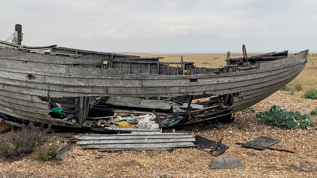
While the size and undeveloped nature of Dungeness give it an air of a land forgotten, it is its long fishing history that creates the appearance of desertion most. The majority of the residences on the Dungeness Estate were originally built for fishermen and their families. Most significantly, ‘the “Watering House”… built in the late nineteenth century to provide accommodation for the family who provided fresh water to passing ships,’ [See Appendix VIII] still stands today as a small and quirky house on the beach.[86]‘Leading up to the 1960s, fishing was a prominent activity in the area and boats could be seen spaced out along the beach opposite the dwellings’, however, since then, the boats have simply been left in a state of ruin and disrepair on the shingle [See Appendix VIII]. Before the war ‘miniature gauge rail tracks were installed on the beach to meet each boat and joined a common track that ran along the present day Dungeness Road’ and, while the completion of the road in 1938 meant the removal of the track, some remnants of this system can still be seen along the beach [See Appendix VIII]. Old wooden winches used to haul the boats over the shingle also still remain, as well as a number of ‘Tanning Coppers’ [See Appendix VIII] used to ‘preserve and dye fishing nets and clothing.’ [87] Whilst fishing is no longer commonplace at Dungeness, its history is still very present and any visitor, without much knowledge of the area, may assume that it only ceased within the last decade, and not 60 years ago. Even though the fishing industry is no longer a significant employer in the area, it has become ingrained into the local culture and adds significantly to the character of the landscape, as it is now difficult to find a large piece of shingle which is not touched by the remains of its history.
The railway has also lefts its mark on Dungeness, from the remaining line that runs for tourists to the residences that it has left behind. ‘During the latter half of the nineteenth century plans had been proposed to develop Dungeness as a major ferry port that would offer faster cross channel crossings than was then possible from its neighbours at Folkestone and Dover.’[88] Despite these plans never being realised, this did not mean the end of public transportation at Dungeness as, in 1881 the railway line between Appledore and Lydd was extended and operated for passengers and goods. Whilst parts of this line were decommissioned in the first half of the twentieth century and defunct parts of the line were removed, it was replaced by ‘the popular Romney, Hythe and Dimchurch light railway’ in 1927, which now lies in its place. However, the tracks themselves are not the only evidence that remains on the shingle as ‘the heritage of the railway … is still represented today in a number of dwellings throughout the estate’ [See Appendix IX].[89] There are around 30 residences at Dungeness created from decommissioned railway carriages purchased by railway workers in the 1920s who had been made redundant. Whilst these make-shift homes have since been ‘converted and extended into permanent residences’ and holiday homes, originally, they were all lived in as they were, and ‘fell into states of disrepair and neglect.’[90] It was the arrival of Derek Jarman in 1986 that created a revival of interest in the area which lead to the renovation and restoration of these carriages. Today they stand on the Dungeness Estate, providing a modern-day use, while still retaining their cultural importance.
Derek Jarman bought his own residence, Prospect Cottage, in 1986 and lived there until his death in 1994 [See Appendix X]. His artistry in creating his own garden there attracted significant attention that helped to place Dungeness on the map outside of conservation and governmental needs. The interest in the area that he inspired only continues to grow. Not only was Jarman a famous film director, artist and author, he was also a gay activist who is still admired by people from all walks of life and for many different reasons. It is this appreciation of him as a person as well as for his talent that continues to inspire people today, which is why many see Prospect Cottage as a place of cultural significance. It is seen as ‘a site of pilgrimage for people from all over the world, who come to be inspired by its stark beauty and by Jarman’s legacy.’[91] This includes celebrities such as the pop group, Pet Shop Boys [See Appendix X] who continue to visit in remembrance of their old friend.
Whilst Derek Jarman’s garden is the most well-known piece of cultural history Dungeness has to offer, and often the first thing people think of, he has actually used the local culture in its creation and as such has tied it all together. With the land so flat, with ‘no woodland, not a tree, nor even a field-wall or fence’ in sight, in addition to shingle being such a notoriously difficult material to work with, Jarman had to be creative in designing his garden.[92] Rather fittingly, as Prospect Cottage was built as a residence for fishermen in the Victorian era, Jarman used the debris from the fishing boats that lay along the beach as garden decoration. He used ‘dead things, rubbish, ruined and, to anyone else, useless objects’ to form his design.[93] He used much of this debris to create posts, stuck vertically upright in the shingle throughout the garden, which ingeniously added height to an otherwise horizontal landscape [See Appendix X]. He also brought plants, some native to the region and some not, to create a natural space. Jarman writes of his surprise at being so ‘happy’ with his own company, but ultimately Dungeness truly gave him a real sense of peace.[94] His desk faced out into the garden so he could see it and feel inspired whilst he worked, and Prospect Cottage’s inspiration can be evidently seen in his later work, for it was here that he shot his 1990 film The Garden and was the subject of his final book, Derek Jarman’s Garden. However, ‘the garden came to life as Derek was dying’ and ‘became part of his healing’ in his final few years; ‘for a man for whom symbolism was really important – it couldn’t be more potent.’[95]
After Jarman’s death, the house and garden remained exactly as he had left them. ‘From poetry etched into panes of glass, to Jarman’s driftwood sculptures and the remarkable garden he coaxed from the shingle, [Prospect Cottage] represents the most complete distillation of his creativity and determination’ [See Appendix X] and this was perfectly preserved until 2018, when his close companion and the inheritor of the property passed away.[96] In January 2020 the UK Charity Art Fund began a crowdfunding campaign to stop the cottage from being sold to a private buyer and by April they had raised over £3.6 million, the largest amount ever from an arts crowd funding campaign. The house will now be looked after by Creative Folkestone, an arts organisation, who will arrange a ‘permanent public programme.’[97] The public will now be able to see inside the house for the first time and Jarman’s garden will continue to exist as both a site of pilgrimage for artists and fans, as well as a perfect example of the cultural significance that Dungeness has to offer.
Whilst none of the cultural uses of Dungeness have individually had any largescale effects on the landscape, when viewed as a collective they add to the unique landscape that it is today. The cultural remnants are all memorials to historical uses of the land and, with the main focus being the preservation and not the beautification of the area, they remain to pay homage to bygone years. Today the cultural aspect attracts as much tourism as the nature reserve and power stations, because that is what makes Dungeness stand apart as a destination from other tourist attractions. The removal of the railway, lighthouse, fishing debris and cottages, would have very little physical effect on the land and the shingle would on the whole return to a relatively unscathed state, however, the impact would be felt by locals and visitors alike, for whom these things make up the character of the area.
Conclusion

Image 5: The East Side of Dungeness Today
Dungeness is a unique expanse of natural shingle that bares its history very openly for all to see. It’s reputation as an untouched and undeveloped landscape holds less truth now than it did a century ago, as much of the shingle has been damaged and the houses, lighthouses and nuclear power stations all stand strong; however, in comparison to the overly developed modern world, the Dungeness landscape is almost like taking a step back in time. Human development has not been allowed to fill every small space it could find here, and nature has been allowed to co-exist in between the less natural elements of the area. Thus, Dungeness is able to retain its status as an untouched and undeveloped landscape as the great expanse of shingle, despite being altered by man, is still a rare site for many in this twenty-first century.
In the long run, despite the remaining structures and the road that runs through the reserve, the long-term effect of the military history in Dungeness is rather minimal. Though at the time it was destructive from an ecological perspective, with the help of the RSPB, all avian wildlife there has been completely rehabilitated and the shingle craters have been gradually filled in and erased. Structures, such as the Sound Mirrors, now taken on by the RPSB, exist today as a memorial to Dungeness as a military site but do no harm and the road now acts as a main throughway for tourists. Moreover, their occupation of the land that was not owned by the reserve further prevented any development on the unprotected shingle. In hindsight, it is clear that the threat they posed in the 1940s and 1950s was actually a blessing in disguise. The nuclear history of Dungeness however is not quite the same story, with the power stations overshadowing the entire reserve with their imposing height in such a horizontal landscape. Until the nuclear power stations are completely removed the extent of the damage cannot be known, however, their weight and concrete foundations alone have caused certain damage to the shingle beneath. Moreover, the potential threat of radiation that the station poses cannot be overlooked. There is evidence of slightly mutated plants growing in the surrounding area, with one even found at the edge of Derek Jarman’s garden. As radiation is invisible, it can be monitored but it cannot be battled, and it has the potential to irreversibly affect the landscape for many years, even after Dungeness B ceases operation. Whilst on a day-to-day basis it has very little affect, even helping to attract birds, it will only be in the long-term, as with the military history, that its real affect will be known.
Arguably, the organisation to have had the greatest effect on the landscape of Dungeness is the RSPB. Without their intervention over the years, both in buying the land, but also in monitoring the work of more potentially destructive organisations, such as the War Office and the CEGB, Dungeness may have become a coastal town like any other. Residential developments would have covered the shingle, leaving no space behind for the birds or flora to exist as they do today, and Dungeness may not have had the opportunity to become a leading site in nuclear power or site of pilgrimage for artists trying to capture the inspiration that it gave to Derek Jarman. The RSPB has provided us, and more importantly nature, with a sanctuary for the natural world, and along with the BO, a place to see rare and special creatures. However, it is important to note that through conservation efforts, the land has been enhanced but also disturbed and it is a manually constructed version of ‘natural’ that exists today. Whilst many may consider the RSPB to have had the least physical effect on the landscape, this is certainly not the case. Their mark has simply been made over a greater area of land instead of in concentrated areas like many of the other developments. The reserve showcases man-made pits, lakes, and islands that were specially constructed, alongside trails, bird hides and benches, all leading to a visitor centre building, complete with car park and road. These developments were created with nature in mind, predominantly avian-nature, and whilst it means that nature can thrive, it is not the same landscape that the RSPB appointed a Watcher to care for in 1896. Nonetheless, they have been forced to adapt the landscape in order to survive, as other uses of the land have contested conservation efforts and, whilst it might not have been entirely crafted by nature, they have done so very successfully.
Culturally, the landscape is no longer untouched, but it is equally fairly unscathed. The preservation of Dungeness has meant the retention of historical artefacts on the shingle, which makes for a very distinctive landscape, but they could be removed tomorrow leaving very little evidence that they were ever there. A more difficult cultural marker to remove would undoubtedly be The Old Lighthouse, however, with five lighthouses having been demolished before it, and no evidence of their presence remaining, it would not be an impossible feat. The same also applies to the railway, much of which has already been removed in the past when operation on it had ceased. Moreover, the quirky little dwellings, including Prospect Cottage, and the fishing debris are not built on particularly strong foundations, therefore, whilst they mark the landscape visually, they have not physically scarred it in any meaningful way. Thus, Dungeness is able to display its cultural relevance and its history without destroying itself in the process.
During the twentieth century, the different uses attracted to Dungeness contrasted considerably with each other. Military need and the aim for more nuclear power completely overshadowed conservation efforts, and cultural landmarks brought more visitors who at the time were considered a threat. Significantly, these different uses only contested each other when isolation and minimal human presence was the aim. In the twenty-first century however, all organisations using the land work extremely well together, now that they have all established their perimeters, and more importantly, the area has shifted into a more tourist friendly mindset. The nuclear power stations, the RPSB and The Old Lighthouse all have visitor centres which charge entry, and Prospect Cottage is due to be converted into cultural museum. The railway is today used as a fun activity for visitors more so than as an actual mode of transport to Dungeness, and many of the little railway carriages and other dwellings have become permanent holiday homes or shops. Whilst the turn towards tourism has created a harmonised operation of the area, it has also left its mark physically. Two pubs and their respective car parks now sit near to the lighthouse, power stations and railway to appease the visitors who expect refreshment on their days out, and the thousands of people who flock there each year slowly erode the shingle on the beach and destroy the plants by walking off the beaten path. Once again it is a matter of weighing up the consequences between the affect it has on conservation efforts each year and the importance of the revenue tourism brings to the area, which enables the conservation efforts and the cultural character of Dungeness to continue to thrive.
Looking ahead to the future, the new-found stability between conservation efforts and other uses should mean that the land is protected well enough that it can survive as a natural habitat, an undeveloped shingle desert and a tourist attraction for decades to come. However, the new threat Dungeness will face is that of Climate Change and rising sea levels. Whilst the Dungeness coastline grows further and further into the sea each year, its flat nature puts up little defence for rapidly rising sea levels and, within the next century or two, it could be flooded. It is currently considered low risk, compared to other parts of the Romney Marsh, but this could change within the next few decades. It is likely that the shingle will be disturbed once again in an effort to defend Dungeness from this threat, with sea defences already being constructed around this part of the coast. It is hard to predict exactly what will happen to the landscape, as its ecological significance may encourage greater efforts to help its survival, yet, on the other hand, its smaller number of inhabitants when compared to other coastal towns may leave it vulnerable. Despite the threats it will face, after surviving such conflicting demands in the twentieth century, it is well equipped to face a new challenge.
Appendix
All images sourced from the Romney Marsh website, unless cited differently
https://theromneymarsh.net/dungenesshistory
Appendix I: Military Maps and Structures

Figure 1: The William Mudge Map of 1801
‘This is regarded as the first official map produced by OS. Known as the Mudge map after William Mudge, Superintendent of Ordnance Survey 1798-1820. It shows the County of Kent at a scale of one inch to a mile.’
– Ordnance Survey information officer


Figure 2: 1867 Map of the Dungeness Batteries


Figure 3: Dungeness No.2 Battery today (rear view)
Appendix II: Dungeness Nuclear Power Stations
Figure 4: Aerial view of Dungeness Nuclear Power Stations
– CEGB Archives

Figure 5: Dungeness Nuclear Power Stations today
-CHS Building and Engineering Services http://www.chsbuilding.co.uk/projects
Appendix III: Maps of the Nature Reserve

Figure 6: Modern map of Dungeness (inclusion of Greatstone for reference point)

Figure 7: Reference point for Walkers Outland
– Geological Society of London Publications
https://qjegh.lyellcollection.or g/content/39/4/333/tab- figures-data

Figure 8: Map of Dungeness Nature Reserve and its trails
– Dungeness nature reserve visitors map
Appendix IV: RSPB Reserve Pits/ Lakes

Figure 9: View of the Reserve from the Visitor Centre
(Example of manmade pit and islands)

Figure 10: Example of birds using the manmade lakes and islands
– Flickr
https://www.flickr.co m/photos/sarfrazh/36961727775
Appendix V: Denge Sound Mirrors

Figure 11: Denge Sound Mirror
– RSPB Dungeness
https://www.rspb.org.uk/reserves-and-events/reserves-a-z/dungeness/

Appendix VI: Dungeness Bird Observatory

Figure 13: Dungeness Bird Observatory (far right) located next to The Old Lighthouse and old lighthouse keepers’ quarters.
– Countryside Classroom
https://www.countrys ideclassroom.org.uk/p laces/2705

Figure 14: Dungeness Bird Observatory
– Dungeness Bird Observatory
http://www.dungen essbirdobs.org.uk/p/our-history.html
Appendix VII: Lighthouses

Figure 15: Wyatt’s Lighthouse c.1900
The old lighthouse keepers’ quarters can be seen wrapped around the base.

Figure 16: The construction of the 1904 lighthouse (The Old Lighthouse) next to Wyatt’s Lighthouse.

Figure 17: The 1904 lighthouse (The Old Lighthouse) today.
Appendix VIII: Fishing Debris

Figure 18: Fishing boats abandoned on the shingle
– Flickr
https://www.flickr.com/ photos/64joe/32869909 778

Figure 19: The Watering House

Figure 20: Abandoned Gauge Rails
https://www.pinterest.co.u k/pin/37084335055903404 3/

Figure 21: An abandoned wooden winch

Figure 22: An abandoned Tanning Copper
Appendix IX: Railway

Figure 23: Railway Carriage Home c. 1935

Figure 24: ‘Railway Cottage’ today

Figure 25: The Old Railway Station

Figure 26: Passenger train at Dungeness

Figure 27: Passenger train at Dungeness with the lighthouse behind
– The Outdoor Guide
https://theoutdoorguide.c o.uk/walks/holiday- property-bond- walks/sibton-park-kent- etchinghill/
Appendix X: Prospect Cottage
Figure 28: Prospect Cottage

Figure 28: Prospect Cottage

Figure 29: Part of the Garden at Prospect Cottage

Figure 30: Derek Jarman’s Garden with the power station behind
– Garden Museum
https://gardenmuseum.org.uk /exhibitions/derek-jarman- my-gardens-boundaries-are- the-horizon/

Figure 31: Poem on the side of Prospect Cottage

Figure 32: The Pet Shop Boys at Prospect Cottage
https://twitter.com/pets hopboys/status/1233795 482171969538?lang=en- gb
Bibliography
Primary Sources
CEGB Archives: Assorted Resources
-
– East Sussex News, 17th December 1981
- – East Sussex News, 24th December 1981
- – Hastings News, 10th December 1981
- – East Sussex News, 24th December 1981
- – South Kent Gazette, 9th December 1981
- – Kentish Express 27th November 1981
- – Kentish Express, 12th November 1981
- – Folkestone Herald, 23rd October 1981
- – Kentish Express, 6th March 1981
- – Sussex Express, 8th May 1981
- – Folkestone, Hythe and District Herald, 12th November 1981
- – Power News, September 1981
- – Rye and District Times, 22nd April 1981
- – Kentish Express, 24th April 1981
-
– Hastings News, 30th July 1981
Heritage Conservation Group Kent County Council: Folkestone and Hythe District
Heritage Strategy, Appendix 2 Case study 4: Dungeness, 2017
Jarman, D., Modern Nature: The Journals of Derek Jarman, (London, 1992)Lyons, W., Countryfile, Dungeness, BBC ONE, 2nd February 2020.
Nicholson, E. M., Birds in England; An Account of The State of our Bird Life andCriticism of Bird Protection, (1926)
Nicholson, E.M., Britain’s Nature Reserves, (1957) Ordnance Survey Information OfficerRSPB Archives: 01.05.50(D1), Dungeness Bird Reserve Correspondence 1954-56, Dungeness Correspondence 1954
RSPB Archives: 01.05.50(D1), Dungeness Bird Reserve Correspondence 1954-56, Dungeness Correspondence 1955
RSPB Archives: 01.05.50(D1), Dungeness Bird Reserve Correspondence 1954-56, Dungeness Correspondence Jan-June 1956
RSPB Archives: 01.05.50(D1), Dungeness Bird Reserve Correspondence 1954-56, Dungeness Correspondence July – Dec 1956
RSPB Archives: 01.05.50(D1), Dungeness Bird Reserve Purchase of and Preservation
RSPB Archives: 01.05.50(D1), Dungeness Bird Reserve Purchase of and Preservation, Dungeness Bird Ringing Committee
RSPB Archives: 01.05.50(D1), Dungeness Bird Reserve Purchase of and Preservation, 01.05.50(D1)
RSPB Archives: 01.05.50(D1), Dungeness Bird Reserve Purchase of and Preservation,01.05.50(D1)
RSPB Archives: 01.05.50(D1), Dungeness Bird Reserve Purchase of and Preservation, 01.05.50(D1)
RSPB Archives: 01.05.50(D1), Dungeness Bird Reserve Purchase of and Preservation, Correspondence Re Purchase of Dungeness Aug 1936 – Jan 1957
RSPB Archives: 01.05.50(D1), Dungeness Bird Reserve Purchase of and Preservation, Paper Relating to Preservation of Dungeness
RSPB Archives: 01.05.50(D1), Dungeness Bird Reserve Correspondence Wardens reports May 1954-56 Jan 1957-58
RSPB Archives: 01.05.50(D1), R.S.P.B. Annual Reports, 1937-1941 RSPB Archives: 01.05.50(D1), R.S.P.B. Annual Reports, 1947-1953
RSPB Archives: 01.05.50(D1), Report of The Watcher’s Committee February to October 1913
RSPB Archives: 01.05.50(D1), Report of The Watcher’s Committee 1914
RSPB Archives: 01.05.50(D1), Report of The Watcher’s Committee 1916-1930
RSPB Archives: 01.05.50(D1), Report of The Watcher’s Committee 1931 and 1932
RSPB Archives: 01.05.50(D1), Report of The Watcher’s Committee 1933 and 1934
RSPB Archives: 01.05.50(D1), Report of The Watcher’s Committee 1935 and 1936
RSPB Archives: 01.05.50(D1), Report of The Watcher’s Committee 1937, 1938 and1939
Secondary SourcesAxell, H., Of Birds and Men, (Sussex, 1992)Charlesworth, M., ‘Derek Jarman’s Garden at Prospect Cottage, Dungeness, and his Avebury Paintings’, Studies in the History of Gardens & Designed Landscapes, 35/2, (2015), pp.172-182
Cocker, M., Our Place; Can We Save Britain’s Wildlife Before It’s Too Late? (2018) Hammond, N., RSPB Nature Reserves, (Bedfordshire, 1984)
Marren, P., England’s National Nature Reserves, (1994)
Marren, P., Nature Conservation, (2002)
Moss, S., A Bird in the Bush; A Social History of Birdwatching, (London, 2004)
Pearson, C., Coates, P., & Cole, T., Militarized Landscapes: From Gettysburg to Salisbury Plain, (London, 2010)
Rothschild M., & Marren, P., Rothschild’s Reserves: Time and Fragile Nature, (Essex,1997)
Samstag, T., For the Love of Birds, (1988), Published by The Royal Society for the Protection of Birds, The Lodge, Sandy, Bedfordshire
Sands, T., Wildlife in Trust: A Hundred Years of Nature Conservation, (2012)
Sheail, J., Nature Conservation in Britain: The Formative Years, (1998)
Sheail, J., Nature in Trust, (1976)
Stamp, D., Nature Conservation in Britain, (London, 1969)
Stoddart, A., Shifting Sands, (2013)
WEBSITES
https://www.bumblebeeconservation.org/short-haired-bumblebee-reintroduction- project/
https://www.rspb.org.uk/reserves-and-events/reserves-a-z/dungeness/
http://www.dungenessbirdobs.org.uk/p/about-us.html
http://www.dungeness-nnr.co.uk/attractions.php
https://www.rspb.org.uk/reserves-and-events/reserves-a-z/dungeness/lade-pits-and- the-denge-sound-mirrors/
https://www.rspb.org.uk/about-the-rspb/about-us/our-history/
https://theromneymarsh.net/assets/fileman/Uploads/Documents/Dungeness_Nature_R eserve_Leaflet.pdf
https://theromneymarsh.net/dungenesshistory https://www.rspb.org.uk/reserves-and-events/reserves-a-z/dungeness/
Visiting Prospect Cottage in Dungeness, Kent, the former home and garden of Derek Jarman. I have many happy memories of visiting Derek here in the late 80s and early 90s. pic.twitter.com/4xRGEnjP4b
— Pet Shop Boys (@petshopboys) February 29, 2020
https://www.dezeen.com/2020/04/03/derek-jarman-prospect-cottage-saved-art- fund/
https://www.artfund.org/get-involved/art-happens/prospect-cottage